Map Creation
  • 230 posts
  • Page 2 of 16
jonboy1967 wrote:
If some city names in some of these counties is necessary. You could look it up easy enough, but if you like i can tell you our major 5 to 20 cities. Whatever input I can have to help.
iTrend wrote:
1-YES, our skills are MUCH better than yours JB.
2-adding MORE than just lakes would be wise. For TExas has a motto "everything is bigger in texas." So, BIGGER (in number) 'things'. Such as a one Texas Stadium. A Longhorn skull. A tumbleweed..etc.

naathim wrote:
Okay, first off, remember this is still a brainstorming map, so it looks ugly and it'll have to be completely redone.

I think I like this rough idea for regions better than the school district one. http://idx-images.cisdata.net/acnt/images/558/AR407558/file_manager/Texas_Map_clear_background.png

More manageable regions I would think. And it poses a helpful solution to the panhandle, by making the regions vertical.

Here's it with the rivers. I just put everything that the survey map had on it, that way there's more options. I also went for some over the top pizzazz that iTrend wanted :P

http://i1154.photobucket.com/albums/p536/drewbrookover/Texasupload_zpsae33c177.jpg

I definitely think the rivers at 66/104 can be conflated, same with 103/101 and 61/64, and that'll do a lot to divide the map and sequester regions, at least in the East. And if the regions in the West are switched to a vertical configuration, I think it'll work out pretty well on division.
naathim wrote:
Well, here's a good start. I think this is a fairly well balanced map. Still a few kinks to work out on gameplay. Yes I know it's 118 territories and that's a bad number. But I can get it to 120 or 116, both of which I think would work well for gameplay/division.

jonboy suggested maybe something with the bigger cities. So I plonked some stars on there to mark their APPROXIMATE locations. I think it might be a bit too busy for an already cramped map though. But I was thinking a n+1 scheme for a special. Every city you control +1 gains you +1 bonus. So two cities gets you +1, three is +2 etc.

Rivers are a teensy hard to see, sorry about that.

Anywho, this is about as far as my skills go. If anybody wants to continue the map, hit me up for the file and it's yours.

And direct link just in case: http://s1154.photobucket.com/user/drewbrookover/media/Texas%20upload%20_zpsz3qrssqu.jpg.html

Spoiler (click to show)
aeronautic wrote:
I don't think 118 is a problem, please see the list of territories / players: http://www.dominating12.com/forum/?cmd=topic&act=view&id=2026#post-30758

You have done a good job of setting up a game play. This is not my strong point, but I do have 2 connectivity suggestions.
I believe this could be a great extra large map and NOT require the use of ports for connectivity, but that means that some parts of the map are currently too isolated and simply putting a bridge between 10 & 16 and at 32 (needed anyway to complete the territory), would open up a little cross map connectivity.

Great work !
Hyd yn oed er fy mod Cymraeg , dim ond yn siarad Saesneg, felly yr wyf yn gobeithio y bydd y cyfieithu yn gywir.
jonboy1967 wrote:
http://i1154.photobucket.com/albums/p536/drewbrookover/Texas%20upload%20_zpsz3qrssqu.jpg


I LOVE this map. I have sent naathim a list of cities for 2-9 players. I think you will find it pretty even on all maps. Lets see what naathim comes up with. He is doing great. Another Ty to you and aero for helping me with this. ";D"
jonboy1967 wrote:
OHHHHHH. Can you put the flag I have for my AV in the top left corner or something. It's the Texas flag
Virtuosity98 wrote:
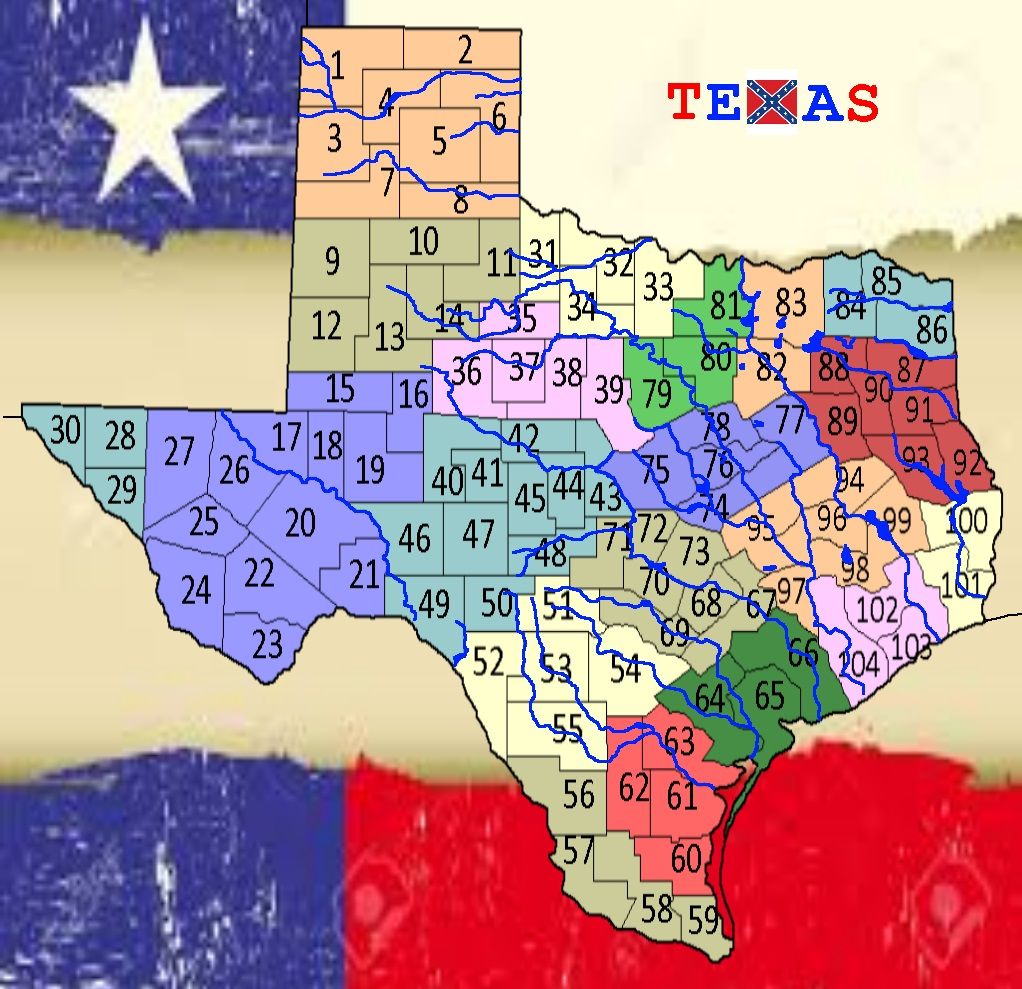
This map looks sooooo interesting!! Great work naathim! I like the way the map can be divided into sections between the rivers etc. I agree with aero's bridge suggestions (except potentially the bridge between 10 & 16 should be between 10 & 22 to lower the amount of traffic going through that tiny yellow region (16/17) and to improve North/South connectivity). The other thing I would say is, if you want to move large distances across this map it will be reeaaally hard, because you would have to move through so many territories. Perhaps a few (no more than 5) airports (maybe even less) could be introduced to improve macro-connectivity. Finally, I think the borders between the following should be made clearer: 85/98, 70/90 (perhaps make a bridge in 70), 65/67. I know they're fairly clear, but some people would definitely fail to notice that they border each other.

To graphically represent my recommendations (yellow rings highlight border clarifications, planes signal approximate airport locations):

Texas Recommendations (click to show)
Sorry about the hideous colours, I had to make the icons noticeable!

Make sure that you only make airports that correspond to real life airports if possible (I don’t really have a clue how many airports are in Texas and how well dispersed they are). Just try to keep them close to where I’ve suggested.

Finally, anyone wishing to take on this map, note that its current width is 1000px (naathim’s width), when it should be 1024px like my picture (someone please correct me if I’m wrong!!). I hope that whoever decides to do the graphics is a patient cartographer, because there are a LOT of territories here, and someone’s going to have to name Every. Single. Last. One. ^^

I’m afraid that’s all I can really give on gameplay. Where’s The_Bishop when you need him??? :D

EDIT: Please debate whether you think the airports are necessary.
It is now Day 8. Please submit your Lynch vote, as well as any Role-specific Day actions you wish to perform (countdown).
Day Actions:
• #LYNCH [player], #NO LYNCH, #ABSTAIN in forum thread.
• Role-specific actions (via PM with V98).


Virtuosity98 wrote:
EDIT 2: Jonboy, I think you have your beloved Texas Flag confused with the Chile flag:

Texas Flag (click to show)
Chile Flag (click to show)
It is now Day 8. Please submit your Lynch vote, as well as any Role-specific Day actions you wish to perform (countdown).
Day Actions:
• #LYNCH [player], #NO LYNCH, #ABSTAIN in forum thread.
• Role-specific actions (via PM with V98).


naathim wrote:
Thanks for the suggestions virt, I think you're pretty right on all of them. I did leave the rivers overlap on 70 and 32 on purpose, in lieu of putting in more bridges. But it's not really intuitive, so bridges it is.

I don't know if the Northeastern river is even needed or not. It doesn't really DO anything other than make travel paths a bit longer.

I think if we do airports, we drop the city idea, even though jb wants that. It'd be really easy to overload the map. And I think the city positions would work decent enough for airports. Spread them out at the big cities (Amrillo 114, Austin 56, Houston 25, Midland 74, Dallas/Fort Worth 88 or 89, and Laredo 6 or Brownsville 1 or 2. ) Those would be my suggested placements for them. But idk if you'd actually need that many or not. Like you posted, 5 should be plenty, N, S, E, W and Central just to provide better connectivity.

And I am LOL'ING like you would not believe at that Chile flag. OMG that's HILARIOUS!!!
Virtuosity98 wrote:
I would say DEFINITELY keep the Northeastern River. Removing it would make the East of the map a featureless block of territories. It gives people more super-regions to go for (although on a map this large it will be hard to get them anyway), thus promoting fun aggressive play.

The cities are well-dispersed, so they could be used instead of my airport suggestions. I guess that's up to the creator's discretion. At least we know that the cities have airports in those locations - for all I know I may have proposed airport territories in the middle of nowhere!

And yes, the whole Texas/Chile flag thing amused me too - I had to share it! ^^ Sorry Jonboy! ;D
It is now Day 8. Please submit your Lynch vote, as well as any Role-specific Day actions you wish to perform (countdown).
Day Actions:
• #LYNCH [player], #NO LYNCH, #ABSTAIN in forum thread.
• Role-specific actions (via PM with V98).


jonboy1967 wrote:
First off. I like the airport Idea. They are everywhere in texas. Every City I gave you an airport naathim. I like that idea as well. Or if you wanted outlying airports, I can come up with a list for you.

Two....Virtuosity...Who does that, compare flags so close. Nobody would have ever known if you would not have said anything...lmao.
jonboy1967 wrote:
ok ok ok. Oxen gave me the flag and I honestly didn't see the difference. My bad....My bad (bows head in shame) my bad.
naathim wrote:
Alrighty. I cleared up most of the ambiguous borders, I think. So everything should be straightened out.

Put in possible airport locations. I put four into the potential superregions, (panhandle, El Paso, south, and East) With one in the north around DFW and one towards the center in Austin.

Territory names and circles added, just wanted to see if everything would fit. It should as long as nobody gets to complicated with the final fonts. It's a bit cramped though. Some territory borders and rivers might need to be adjusted.

JB will have to let me know if those territory names are good enough. I used county names almost exclusively, except for the two territories that I made up (alpine and van horn). And tried to choose ones that 1) would fit and 2) show more of the Texas vibe. I think for the most part, it works pretty well.

Direct link: http://i1154.photobucket.com/albums/p536/drewbrookover/Texas%20upload%20_zpsiv1tl2g0.jpg

Spoiler (click to show)