a.k.a. Psymon's map #4 - 78 territories
  • 98 posts
  • Page 1 of 7
PsymonStark wrote:
I'll try to stick to the example map as much as possible... Here we have a map of the Baltic countries.

http://www.bluemelon.com/photo/5197493.jpg

The first thing you'll probably see here is that I was unable to fit the minimap. The only way to add it would be where the title is now, and would be too small and busy. Therefore, I added the bonuses to the regions, basketball map style, trying to minimize the impact on the map but keeping them well visible and distinguishable.

Other than that, >6p map with 78 territories, 12+2 big and relatively defensible regions (3 with 2 borders, 3 with 3 borders, 6 with 4 borders).

So now everyone can comment on the gameplay :)
Living proof that everyone can be a brilliant great good decent cartographer.
The_Bishop wrote:
Gorgeous Map! My best congrats Psymon!
At the first sight I would say the game-play looks absolutely good to me, but not analyzed yet.
I would like to ask... "Why Sweden divided? And why Latvia and Lithuania merged?" Just questions. I like the special bonuses for Bornholm and the Kaliningrad Exclave.
I am okay with the bonuses written on the land, without the mini-map. I don't like so much the circles on the sea; referring to the islands: Aland, Gotland and Bornholm. I think they should stay at least half on the land and half on the sea.
Apart from that... Good job!
«God doesn't play dice with the World» ~ Albert Einstein
UltrasPlot wrote:
Im gonna take a guess here and say that he split Gotaland and Sweden proper so as to avoid a massive undefendable hyperregion. IDK about Latvia and Lithuania though.
Matty wrote:
Gameplay?
Most important things first: there is no territory labelled as "bewere, here be Fendi".

Where is that territory
"Strength doesn't lie in numbers, strength doesn't lie in wealth. Strength lies in nights of peaceful slumbers." ~Maria
UltrasPlot wrote:
also Russia should be +4 imo, more similar to Estonia than Osterland when relatively compared, both Gotaland and Svealand should be +5 rather than Svealand +4, other than that get this into beta faster than cbt's Anchor Bay, I wanna play!!!

EDIT: nevermind about Svealand, didn't see that Gotaland had 9 territories as compared to 7. Also miscounted borders.
PsymonStark wrote:
@Bishop, Sweden is divided because I didn't want a 16 territory region, and I could do it without dramatically increasing the number of borders. Also, Latvia/Lithuania are together because they would form 2 regions with 4 borders each, Lithuania with no interior territories and Latvia with only one. With this outline it is very similar to the other +5 region (Gotaland, Southern Sweden). I liked the pseudosymmetry given by the bigger region, both 5 regions with a northern 4 and three 3 regions outside and a common southern 4.

@Matty, hopefully Fendiland is somewhere up north, and not in the map :P Otherwise I may have to put a "Here be Fendi" notice like the one in the Oregon Cities map...

@Ultra, Osterland and Belarus are the easiest regions of the map, they are both on the eastern side. I put Russia a +3 because it's in a corner, bordered by both easiest regions and has a possible extra +1 (+2) with Kaliningrad.
Living proof that everyone can be a brilliant great good decent cartographer.
UltrasPlot wrote:
Exactly. Russia is like neither. Also, Kalinigrad and Russia is like a reverse Asia-region, +5 with SIX borders. I'd rather have it +6...
---
EDIT: to put it into comparison, Denmark is so much easier to hold, even with Bornholm, when compared to Rossiya WITHOUT Kalinigrad. 4 borders - Skane, Szczecin, Nordiylland, Schleswig-Holstein with an easy ticket into Deutschland... Rossiya with KGD is no match for the superregion possibilities and defensibility of Denmark.
PsymonStark wrote:
I don't think you got my point. Anyway, even if with the formula Russia+Kal is 5.07, I think regions with many borders aren't well calculated.

Well, it can be perfectly a 4 too, let's see what other people have to say about this.
Living proof that everyone can be a brilliant great good decent cartographer.
The_Bishop wrote:
Thanks PsymonStark I got your point. I think we are missing large maps with very large regions, that is a possible feature. By the way I like the equilibrium of the two biggest regions giving +5. Your style is so sober and I wont ask you to change it. It's just so nice as it is.

Honestly I think a Psymon's map doesn't require my analysis so much. But if you ask... Yes, I absolutely agree to give a +4 bonus to Russia. The Formula doesn't work properly for a region that is divided in two detached parts, being much harder than a normal region. For Denmark it's different, because there you just need to push in Skane, so the bonus is perfect as it is.

And about pushing... I had noticed that "Northern Sweden" can reduce its borders by pushing in Ostergotland (Southern Sweden). So I am asking, are you sure you want to keep Orebro and Vastra Gotaland disconnected? Just questions. Still congrats my dear.

«God doesn't play dice with the World» ~ Albert Einstein
PsymonStark wrote:
Oops sorry, I missed that one, Bishop. I took the river between the lakes as I found it on the map I took, but I guess it could be bordering if you guys think it's better. I don't really see a big deal with any of the options.

As no one else has been interested by the map gameplay, I just will add the first graphic draft. Circles are not shown here, but the suggestion of moving some of them has been addressed.

Baltic06 (click to show)
Living proof that everyone can be a brilliant great good decent cartographer.
UltrasPlot wrote:
And I see Russia is +4. Can't wait for it even more now!

Also we can just throw this into beta, it's a Psymon map.
PsymonStark wrote:
Lol Ultras, I'm afraid it doesn't work like this :P
Living proof that everyone can be a brilliant great good decent cartographer.
The_Bishop wrote:
Well, nice graphics, but I will let others to comment on it.

--------

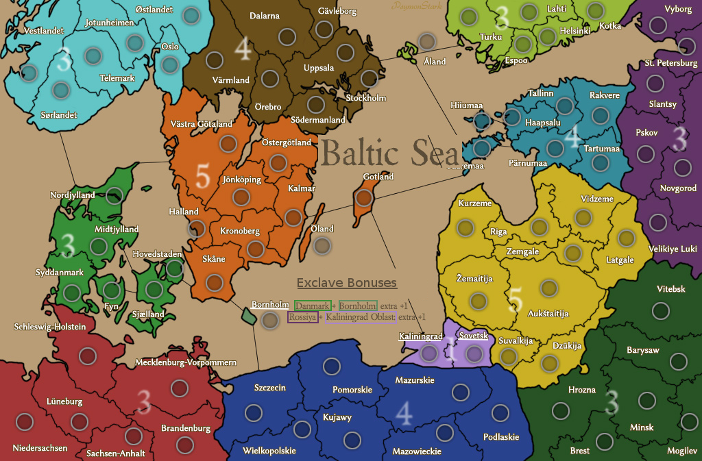
Personally I don't like when a region can reduce his borders conquering a territory of another region: like Asia + Ukraine in World Classic; in this case is "Northern Sweden" + Ostergotland. Also, there are territories bordering trough the sea hundreds of kilometers distant, how a river cannot be passed? Just for logic. I mean, in other maps there are no better solution but here I don't think you need to use impassible rivers.

--------

Some more critiques about the general lay-out.

Personally I delayed some minutes to understand the meaning of the special extra bonuses given for conquering the exclaves. First, I didn't know what Bornholm is, before seeing this map. Also, the region names are not in English and this take some seconds more to me to understand that Rossiya means Russia. Plus I need to search where Russia is in this map, for anyone not expert of European geography it's very hard. Also, how people know that Kaliningrad Oblast is referring to the whole region and not only the territory of Kaliningrad? Supposing that they know what "Oblast" means.

Since I suggest that regions names should be added on the land, OR, region colors should be added in the legend. Something like this:
Image.
Or everything you can do to make it more clear.
And I think Russia and K.Oblast regions should have more similar colours as it is for Denmark and Bornholm.

Also, I appreciate Psymon's punctiliousness on reporting the correct names in local languages, But... I think it's better to use English names for the regions (not the territories, just the regions). "Rossya" is weird for me, I have never seen it before, just because it is normally written using Cyrillic script (Россия), since that is not the real name, but just a weird transliteration in Latin script.

--------

That's all ;)
«God doesn't play dice with the World» ~ Albert Einstein
PsymonStark wrote:
Will probably touch Örebro for the next update.

Neither did I know about Bornholm before making the map.

If someone finds a territory called St. Petersburg (and maybe Novgorod) and doesn't know where is Russia... I don't think anything will make it better for him.

I agree with the region naming anyway. Both of the exclaves have the name on them (Bornholm-Bornholm & Kaliningrad Oblast-Kaliningrad) so it's easier to see. And the Oblast has two territories because it's of the same colour, bonused 1, and it's not called the same as the individual territory. I don't know, I think it's pretty straight-forward, not different to other maps where some people doesn't know what the anchors mean.

If I change the color (darker purple), it would be rejected by the resemblance to Polska blue. I can try to tune it a bit. They are anyway the only purples on the map.
Living proof that everyone can be a brilliant great good decent cartographer.