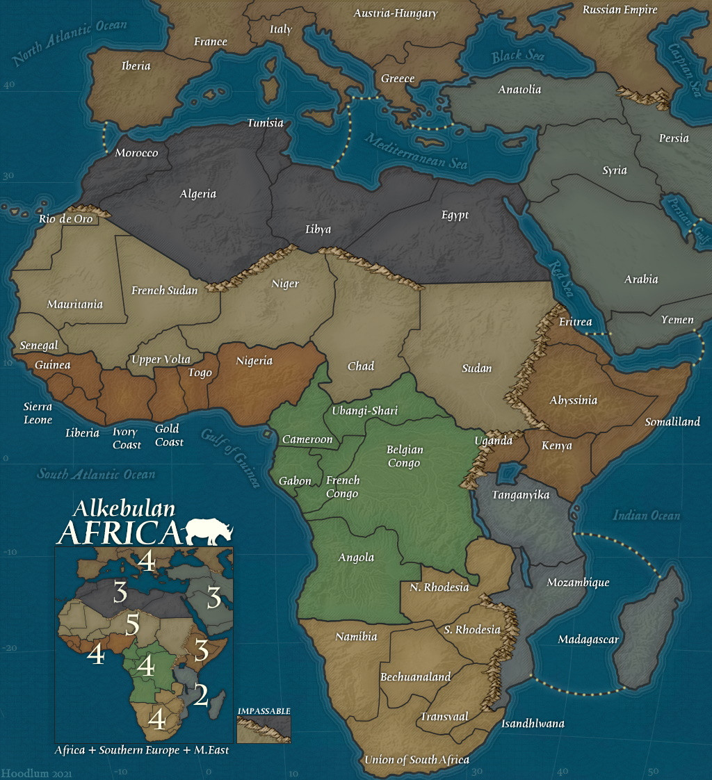
Alright, read the latest responses and tried to adjust the map.
i have multiple solitions, but dont know what is the best one.
here i took a normal pencil 9-7 pixels strong and dark brown colored. some lines are re-drawn two times, so they look a bit darker. i kept them like this, so that u can compare what lines are better.
here i went in the other direction. i took very thin pencil 1 pixel and black:
and here the same pencil, but with some filters making the black lines a engulfed by a thin white lines, its my fav.
Basicly topograph and polotical maps dont have many lines to distinguish between regions, they just rely on different colors. i can do it here aswell, just delete the black lines and let different colors divide the regions, but then i wont have a possibiloty to divide territories. therefore i am forced to use some kind of lines for regs and ters.
regarding gameplay: well, i basicly used the real regional borders and drew ter borders by myself, ofc tried to follow geographical patters a bit, like rivers and thik mountains. theoreticaly i could add the additional bonuses proposed earlier to make the gameplay less plain.
Alright, read the latest responses and tried to adjust the map.
i have multiple solitions, but dont know what is the best one.
here i took a normal pencil 9-7 pixels strong and dark brown colored. some lines are re-drawn two times, so they look a bit darker. i kept them like this, so that u can compare what lines are better.
[spoiler][img]https://i.imgur.com/1hFdy58.jpeg
[/img]
[/spoiler]
here i went in the other direction. i took very thin pencil 1 pixel and black:
[spoiler][img]https://i.imgur.com/FnEmvmM.jpeg
[/img]
[/spoiler]
and here the same pencil, but with some filters making the black lines a engulfed by a thin white lines, its my fav.
[spoiler][img]https://i.imgur.com/ipumKQC.jpeg
[/img]
[/spoiler]
Basicly topograph and polotical maps dont have many lines to distinguish between regions, they just rely on different colors. i can do it here aswell, just delete the black lines and let different colors divide the regions, but then i wont have a possibiloty to divide territories. therefore i am forced to use some kind of lines for regs and ters.
regarding gameplay: well, i basicly used the real regional borders and drew ter borders by myself, ofc tried to follow geographical patters a bit, like rivers and thik mountains. theoreticaly i could add the additional bonuses proposed earlier to make the gameplay less plain.
"vorple: the real strategy comes when you cant just win cuz you got lucky and got the big card stack"

![[image]](https://i.imgur.com/fTyoRuV.jpeg)
![[image]](https://i.imgur.com/1hFdy58.jpeg)
![[image]](https://i.imgur.com/FnEmvmM.jpeg)
![[image]](https://i.imgur.com/ipumKQC.jpeg)
![[image]](https://i.imgur.com/9WodVK9.jpeg)
![[image]](https://i.imgur.com/IEZzrLx.jpeg)